 THE FIRE LAB · OFFENSIVE DEFENCE
El Niño has not peaked yet. Pontianak is already burning.
Forecasters call this cycle unprecedented and give it a better than even chance of being the strongest since records began. The peak is three months away. The fires the models predict for November are already on the ground in Borneo, and the map of where they go next runs through every region this company works in.
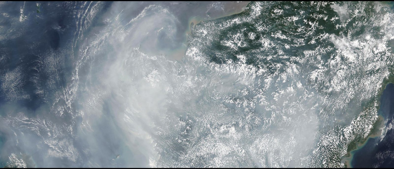
On the third of September the visibility at Supadio airport, outside Pontianak in West Kalimantan, came down to about a hundred metres. Four days later the city's schools stopped teaching in person and moved online, because the air quality index had gone past nine hundred, which is roughly three times the level at which the scale stops bothering to distinguish between bad and worse. The smoke had by then crossed the border into Sarawak and Sabah, reached Kuala Lumpur, Singapore and Brunei, and on the fifth arrived over Manila. The ASEAN haze centre had already raised its regional alert to level three, the highest it has, on the twenty sixth of August.
Roughly two hundred thousand hectares had burned in Indonesia by the end of July. That figure does not include August. A firefighter with the Manggala Agni brigade in Kalimantan told the Australian broadcaster ABC this week that the conditions are worse than 2015. The forestry minister put it another way. The battle, he said, is September.
That is worth sitting with, because in the forecasts, September is early.
WHAT THE FORECASTERS ARE SAYING
The American weather service declared El Niño on the eleventh of June. By the middle of August its Climate Prediction Center was giving the event a greater than ninety per cent chance of being very strong through the northern winter, and a sixty nine per cent chance of exceeding every El Niño in the record, which goes back to 1950. On the twenty first of August the head of long range forecasting at the UK Met Office, Professor Adam Scaife, described it in language forecasters do not usually use. He said he had never seen an El Niño signal this intense in his models, and called the event unprecedented.
The number behind that is the sea surface temperature in the central Pacific. A typical El Niño lifts it one to two degrees above normal, and two is considered a very big event. The Met Office forecasts now show more than three. The World Meteorological Organisation's multi-model update of the third of September puts the September to November average at 3.6°C, with the peak still to come in November and December, and notes that the individual models agree with each other closely enough that confidence is high.
The mechanism is old and simple. In a normal year the trade winds push warm water west across the Pacific, and the rain follows the warm water, which is why Indonesia has rainforest. In an El Niño year the winds weaken, the warm water slides back east towards South America, and the rain goes with it. The regions that lose the rain are the ones that had it before. The rain moves. What is left behind dries out, and then it burns.
WHERE THE MAP GOES
Both agencies publish the same list of regions at heightened risk of drought: Indonesia and the western Pacific, north-eastern Australia, India, Central America, tropical South America and the Amazon, and southern Africa. It is not a uniform signal. Parts of the southern United States and southern South America are more likely to be wet, and East Africa is expecting rain heavy enough to flood.
On the drought side, the signal is already visible on the ground.
India's monsoon finished August nearly fourteen per cent below normal, with forty seven per cent of the country's districts in deficit. The India Meteorological Department expects September to be below normal too, and does not expect El Niño to weaken until February or March.
The European Commission's crop monitoring service reported on the third of September that the drought in Central America's dry corridor has already taken out this year's maize and bean harvests, and that drier than average conditions are now emerging across South Africa, Namibia, Botswana, Zimbabwe, Mozambique and Madagascar, with the planting season due to open in October.
Southern Africa has seen this before. The 2015–16 El Niño gave South Africa its driest year on record. The maize harvest fell by thirty eight per cent in 2016 and Zimbabwe's by sixty three. The veld fire season that followed was severe. A dry summer does not only fail a crop. It leaves a standing fuel load across the whole landscape for the next winter.
This company makes its product in South Africa. That is not a detail we put in for colour.
THE THING ABOUT PEAT
The reason Indonesia matters to this readership more than any other region on the list is what is underneath the fire.
In 2015, the last comparable cycle, more than two and a half million hectares of Indonesia burned between June and October. A third of it was peatland. The World Bank put the cost at sixteen billion dollars, nearly two per cent of the country's economy that year, and more than twice what it cost to rebuild Aceh after the tsunami. The fires released around one and three quarter billion tonnes of carbon dioxide equivalent. On the worst days, by the World Resources Institute's count, they were putting out more than the entire American economy.
Peat does not burn like grass. It smoulders. The fire goes down into the ground and moves through it, and the embers can be metres below the surface with nothing visible on top. The Manggala Agni firefighter quoted above made the point that matters: if it is not put out completely, down to the point where the smoke stops, it comes back. Water poured on the surface of a peat fire does what water poured on a compacted waste pile does. It runs across the top and drains away, and the combustion continues underneath.
We have written about that twice this month, once from a farm outside Johannesburg and once from a waste transfer station in Neasden. The reader who has followed those two pieces will recognise the third. It is the same category of fire, at the scale of a province.
THE KNOCK-ON THAT IS ALREADY IN FORCE
An event this size does not stay inside the weather. The Panama Canal Authority cut the maximum draft for its largest locks to forty eight feet on the second of September and will cut it again to forty seven and a half on the first of October, and has reduced daily transits through both sets of locks. Its own statement blames the El Niño event by name. That is the canal beginning to ration itself in the rainy season, ahead of a dry season that has not started. Anyone with product moving between the Atlantic and the Pacific should already be reading their freight quotes differently.
THE UNCOMFORTABLE TIMING
The peak is November or December. The effects run well into 2027, which the Met Office now expects to replace 2024 as the warmest year in the global record. India's monsoon deficit will not correct before spring. Southern Africa's rains, if they fail, fail between now and March, and the fuel that leaves behind is still standing in August. Indonesia's fire season, which normally closes with the rains in October, has an unusually good chance of not closing.
None of that is a prediction of any particular fire. It is a description of the conditions the next year's fires will start in.
Three questions worth asking this week of any operation with exposure across Southeast Asia, southern Africa, Central America or the Amazon. Does your risk planning treat the next twelve months as elevated, or as business as usual? If the latter, what has to happen before it changes? And for peat, bagasse, baled crop, compacted waste and every other fuel that burns from the inside, is water applied from above still the whole plan, or has that conversation moved on?
SOURCES
NOAA Climate Prediction Center, ENSO diagnostic discussion, 13 August 2026 · UK Met Office, 11 June and 21 August 2026 · World Meteorological Organisation, Global Seasonal Climate Update, 3 September 2026 · BMKG hotspot data via Antara, 4 September 2026 · ASEAN Specialised Meteorological Centre, 26 August 2026 · ABC News Australia, 7 September 2026 · India Meteorological Department, 31 August 2026 · European Commission Joint Research Centre, 3 September 2026 · World Bank, The Cost of Fire, 2016 · World Resources Institute, October 2015 · Panama Canal Authority advisory, September 2026 · Daily Maverick, 31 May 2026, on the 2015–16 southern African harvest.